
↓
 

Panama City Land Surveying

Local Land Surveyors in Panama City, Florida

Panama City Land Surveying
  • Home
  • ALTA Survey
  • Boundary Surveying
  • Construction Survey
  • Drone LiDAR Mapping
  • Elevation Certificate | Flood Survey
  • Land Surveying
  • Topographic Survey
  • Blog
  • Contact Us
Home - Page 4 << 1 2 3 4 5 6 … 9 10 >>

Post navigation

← Older posts
Newer posts →

What Is a Topographic Survey and When Do You Need One?

Panama City Land Surveying Posted on May 27, 2026 by PCBSurveyorMay 24, 2026
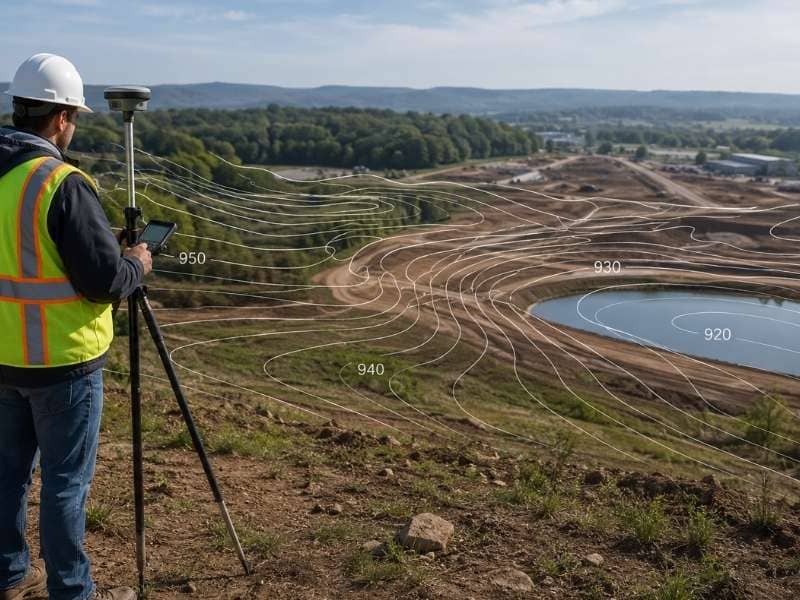
Surveyor using GPS equipment on a development site with elevation contour lines showing the shape and slope of the land

Before anyone builds or designs anything on a piece of land, they need to know what that land actually looks like. That is exactly what a topographic survey does.

A topographic survey measures and maps the physical features of a property. It records the shape of the ground, the height of the land at different points, and everything sitting on it, both natural and man-made. Engineers, architects, and contractors use this map before any project begins.

What Does a Topographic Survey Show?

A topographic survey captures two things: what is on the land and how the height of the land changes from one spot to another.

Natural Features

  • Hills, ridges, and valleys
  • Streams, ponds, wetlands, and drainage channels
  • Tree lines and large areas of vegetation
  • Rock formations and changes in soil

Man-Made Features

  • Existing buildings and structures
  • Roads, driveways, and parking areas
  • Fences, walls, and utility poles
  • Underground utility lines (when marked by the utility company)

Elevation and Contour Lines

Elevation is simply how high or low a point of land is. During a topographic survey, surveyors collect hundreds or thousands of elevation readings across the property.

Those readings are used to draw contour lines on the map. A contour line connects all the points that share the same elevation. When contour lines are close together, the land is steep. When they are spread apart, the land is flat or gently sloping. This makes it easy to see how water will move across a property after it rains.

When Do You Need a Topographic Survey?

You need a topographic survey before designing or building on land where the slope, drainage, or ground features are unknown. It is also required for flood studies, stormwater permits, and most commercial site plan applications.

Before Any Site Design

Architects and engineers cannot design a site correctly if they do not know the shape of the land. A house built without this information can end up with water draining toward the foundation, a driveway too steep to use, or a septic system in the wrong spot. A topographic survey helps the design team avoid all of those problems.

For Drainage and Stormwater Plans

When you build on land, rainwater behaves differently than before. Local governments require developers to show how water will drain off the finished site. Engineers use topographic data to plan retention ponds, drainage channels, and culverts that manage stormwater safely.

For Flood Zone Studies and Permits

If a property is near water, a topographic survey is often required for a flood study. Accurate elevation data helps determine if the land sits in a flood zone. Many local governments also require a topo survey before approving permits for new subdivisions and commercial developments.

For Grading and Landscaping

Contractors doing large grading or landscaping work use topographic data to calculate how much soil needs to be moved. This helps them plan more accurately and avoid costly surprises on the job.

What Does the Final Map Look Like?

The finished product is usually a digital map file in CAD or GIS format. Engineers and architects use it as the starting point for all their design work.

The map includes:

  • Contour lines at set height intervals, usually every 1 or 2 feet
  • Spot elevations at key locations like building corners and drainage points
  • A legend, a scale, and a north arrow
  • The licensed surveyor’s stamp and signature

Smaller residential projects also usually include a printed copy of the map.

How Does It Compare to Other Surveys?

Survey TypeWhat It Does
Topographic SurveyMaps the height and features of the land
Boundary SurveyShows where the property lines are
Construction SurveyMarks where a building or road will be built
As-Built SurveyRecords what was actually built after construction

A topographic survey almost always comes before a construction survey. The topo gives engineers the data they need to create a design. Once approved, a construction surveyor marks the site based on that design.

How Much Does a Topographic Survey Cost?

A topographic survey for a home lot usually costs between $500 and $2,000. Larger properties can range from $2,000 to $8,000 or more, depending on size, terrain, and the level of detail needed.

Key factors that affect the price:

  • Acreage. More land means more measurements and more time.
  • Terrain. Wooded or hilly sites take longer to work through.
  • Level of detail. A 1-foot contour interval survey takes more time than a 2-foot one.
  • File format. Specific CAD or GIS formats may add time to the process.

Finding a design problem on paper is always cheaper than finding it after construction has started.

How Is a Topographic Survey Done?

A licensed surveyor and a field crew visit the property and collect elevation readings using GPS equipment, robotic total stations, or drones with LiDAR scanning. The data is processed back at the office, where software creates the contour lines and final map. Depending on the project size, this takes anywhere from a few days to two weeks.

According to the American Society of Civil Engineers (ASCE), inaccurate elevation data is one of the top causes of home flooding and foundation damage in the United States. A topographic survey is the first step in preventing those problems.

Frequently Asked Questions

Do I need a topographic survey for a small home addition? 

Usually not. But if the project involves grading, a foundation on a slope, or drainage concerns, your engineer or local building office may request one.

Can a topographic survey become outdated? 

Yes. If major grading or construction has happened on the property after the survey was done, the map may no longer be accurate. Most engineers prefer data that is no more than a few years old.

How accurate is a topographic survey? 

Ground-based surveys are accurate to within a fraction of an inch. Drone surveys are accurate to within 1 to 3 inches, which works well for most grading and planning but may not be precise enough for detailed engineering.

Is a topographic survey the same as a contour map? 

No. The survey is the process of collecting elevation data. The contour map is the finished drawing that comes from that data.
Posted in land surveying | Tagged topographic survey

What Is a Construction Survey?

Panama City Land Surveying Posted on May 25, 2026 by PCBSurveyorMay 24, 2026
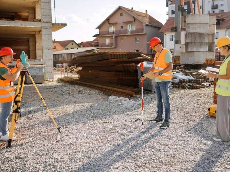
Construction survey team on active jobsite

A construction survey places physical markers on a construction site to guide the building process. A licensed surveyor visits the site and sets stakes, hubs, and reference points that show contractors exactly where to build, how high to build, and how to shape the land. Without these markers, even a well-designed building can end up in the wrong spot.

Also called a construction staking survey or site layout survey, this is one of the most important steps in any building project. Yet many property owners do not know it exists until something goes wrong.

What Does a Construction Survey Do?

A construction survey takes an approved design plan and turns it into real, physical points on the ground. Think of it as a connect-the-dots guide for your contractor. The surveyor marks three main things:

  • Where to build. Horizontal stakes show the correct position of building corners, roads, parking areas, and utility lines.
  • How high or low to build. Vertical grade stakes show the correct elevation for foundations, floors, and drainage.
  • How to shape the land. Grade markings guide earthwork crews so water drains away from the structure correctly.

Once these markers are in place, contractors can begin grading, excavating, and building with confidence that everything lines up with the approved plans.

When Do You Need a Construction Survey?

You need a construction survey before any ground is disturbed on a new building, road, utility line, or site improvement. It is required for residential and commercial projects to confirm that work is placed correctly according to engineering plans and within legal property boundaries.

Residential Projects

  • New home construction
  • Home additions and garages
  • Swimming pools and retaining walls
  • Driveways and septic systems

Commercial and Civil Projects

  • Office buildings, warehouses, and retail centers
  • Parking lots and access roads
  • Stormwater systems and drainage work
  • Road construction and utility installation

If your project requires a building permit, there is a good chance your local government will also require a construction survey before issuing a certificate of occupancy.

Why Is a Construction Survey Important?

A construction survey prevents costly building errors. Without one, structures can be built in the wrong location, violate setback rules, cross property lines, or drain improperly. These mistakes can lead to partial demolition, legal disputes, and failed inspections that delay or stop a project completely.

Skipping a construction survey might seem like a way to save money upfront. In reality, it opens the door to problems that cost far more to fix later. Here are the most common risks:

  • Setback violations. Most zoning codes require buildings to sit a certain distance from property lines. If a structure is placed even a few feet too close, the owner may be forced to tear down or modify it.
  • Encroachments. Building on a neighbor’s property, even accidentally, creates serious legal problems that can take years to resolve.
  • Drainage failures. Improper grading sends water toward foundations instead of away from them, causing flooding and long-term structural damage.
  • Permit issues. Many local governments require survey documentation before approving a final inspection. Without it, the project cannot be legally occupied.

According to a study by FMI Corporation, rework caused by layout errors accounts for about 5% of total construction costs on average. On a $300,000 home, that is $15,000 in avoidable mistakes.

What Is Included in a Construction Survey?

A construction survey is not a single visit. On most projects, the surveyor returns to the site several times as different phases of construction begin.

Initial Control Points

The surveyor first establishes horizontal and vertical control points. These are reference benchmarks placed at known coordinates and elevations. All other stakes on the site are measured from these points.

Construction Staking

Once control is set, the surveyor stakes out the specific elements of the project. This includes:

  • Building corners and foundation lines
  • Curb and gutter alignment
  • Utility trench centerlines
  • Retaining wall locations

Grade Stakes

Grade stakes tell equipment operators exactly how much soil to cut or fill in each area. Each stake is marked with a number showing how many feet to cut down or build up to reach the correct elevation.

Field Notes and Digital Files

After staking, surveyors provide field notes and digital files, usually in CAD or GIS format. These documents are part of the permanent project record and may be required by lenders or permitting agencies.

How Much Does a Construction Survey Cost?

A construction survey for a residential project typically costs between $500 and $2,500. Commercial projects range from $2,000 to $10,000 or more depending on size, terrain, and complexity. Large infrastructure projects can cost significantly more.

Several factors affect the final price:

  • Project size. A larger footprint means more stakes and more time in the field.
  • Terrain. Wooded, steep, or swampy sites take longer to work through than flat, open ones.
  • Number of site visits. Most projects require the surveyor to return at multiple phases.
  • Local rates. Surveying costs vary from one region to another.

The cost of a construction survey is small compared to what it protects. Catching an error before concrete is poured is always cheaper than fixing it afterward.

Who Performs a Construction Survey?

Only a licensed Professional Land Surveyor (PLS) is legally authorized to perform a construction survey. Most states require a four-year degree, years of supervised field experience, and passing the national exams administered by the National Council of Examiners for Engineering and Surveying (NCEES).

Contractors can perform basic layout using plans, but they cannot certify the legal position of a structure relative to property lines. Using an unlicensed layout carries significant legal and financial risk.

According to the U.S. Bureau of Labor Statistics, approximately 44,000 licensed surveyors are employed in the United States.

Frequently Asked Questions

Is a construction survey the same as a boundary survey?

No. A boundary survey determines legal property lines and places permanent corner monuments. A construction survey uses those lines as a reference, then lays out where the improvements will be built. Both are often needed on the same project, with the boundary survey completed first.

How long does a construction survey take? 

For a standard single-family home, field work typically takes one to two days. Larger commercial projects may require several days to weeks, with the surveyor returning at phases such as clearing, foundation, utilities, and paving.

Do I need a construction survey for a small addition? 

It depends on your local building codes. Many municipalities require setback verification before issuing a permit. Check with your local building department before starting any work.

Posted in construction | Tagged construction survey

Welcome to Panama City Land Surveying

Panama City Land Surveying Posted on August 18, 2017 by PCBSurveyorApril 7, 2020

This site is intended to provide you with information on Land Surveying in the Panama City, FL and Bay County area of Florida. If you’re looking for a Panama City Land Surveyor, you’ve come to the right place. If you’d rather talk to someone about your land surveying needs, please call our local number at (850) 640-6404 today. For more information, please continue to read.

land surveyingLand Surveyors are professionals who make precise measurements to determine the size and boundaries of a piece of real estate.  While this is a simplistic definition, boundary surveying is one of the most common types of surveying related to home and land owners. If you fall into the following categories, please click on the appropriate link for more information on that subject:

Panama City Land Surveying services:

    1. I need to know where my property corners or property lines are. (Boundary Survey)
    2. I have a loan closing or re-finance coming up on my home in a subdivision. (Lot Survey)
    3. I need a map of my property with contour lines to show elevation differences for my architect or engineer. (Topo Survey)
    4. I’ve just been told I’m in a flood zone or I’ve been told I need an elevation certificate in order to obtain flood insurance or prove I don’t need it. (Elevation Certificate)
    5. I’m purchasing a lot/house in a recorded subdivision. (Lot Survey – See Boundary Survey if you’re not in a subdivision.)
    6. I’m purchasing a larger tract of land, acreage, that hasn’t been subdivided in the past. (Boundary Survey)

Contact Panama City Land Surveying services TODAY at (850) 640-6404.

Posted in boundary surveying, elevation certificate, land surveying, land surveyor | Tagged boundary survey, land surveyor, land surveyor nashville tn, Panama City Land Surveying

Post navigation

← Older posts
Newer posts →
Get Quote Button
Panama City Land Surveying<
Panama City, Florida
Phone: (850) 640-6404

Privacy Policy | Terms of Use

Web Development and SEO by:
AuburnBusiness.com, LLC

The owner of this website, Boxer Survey USA, provides coordination of professional land surveying and engineering services in all 50 states. The professional surveying and engineering services provided to you will be conducted by fully licensed professionals in your state.

©2026 - Panama City Land Surveying - Weaver Xtreme Theme
↑