
↓
 

Panama City Land Surveying

Local Land Surveyors in Panama City, Florida

Panama City Land Surveying
  • Home
  • ALTA Survey
  • Boundary Surveying
  • Construction Survey
  • Drone LiDAR Mapping
  • Elevation Certificate | Flood Survey
  • Land Surveying
  • Topographic Survey
  • Blog
  • Contact Us
Home - Page 2 << 1 2 3 4 … 9 10 >>

Post navigation

← Older posts
Newer posts →

How to Read a Plat Map

Panama City Land Surveying Posted on June 10, 2026 by PCBSurveyorMay 27, 2026
Two professionals reviewing a property plat map and survey documents to understand lot boundaries and land details

If you have ever looked at your property documents and found a page covered in lines, numbers, and small text, you were probably looking at a plat map. At first glance, it can look confusing. But once you know what each part means, a plat map becomes one of the most useful documents a property owner can have.

What Is a Plat Map?

A plat map is an official drawing that shows how a piece of land has been divided into individual lots. It is created by a licensed land surveyor, reviewed by local authorities, and recorded with the county. Once recorded, it becomes a legal document that defines the size, shape, and location of every lot in a subdivision.

When a developer divides a large parcel of land into smaller lots for homes or businesses, they are required to create a plat. That plat is what gives each individual a lot its legal identity.

Where Can You Find Your Plat Map?

Plat maps are public records. You can find yours in a few places:

  • Your county property records office. Most counties keep plats on file and allow public access, either in person or online.
  • Your county’s official website. Many counties now offer a searchable online database of recorded plats.
  • Your closing documents. If you purchased your home through a title company, a copy of the plat may have been included in your closing package.
  • Your deed. Your property deed often references the name and page number of the recorded plat, which you can use to look it up.

Key Elements of a Plat Map

The Title Block

Every plat has a title block, usually in the top corner. It includes the subdivision name, recording date, the surveyor’s name, and the county and state where the land is located.

The North Arrow and Scale

The north arrow shows which direction is north. The scale tells you the relationship between the drawing and real life. A scale of 1 inch equals 50 feet means every inch on paper represents 50 feet on the ground. Always check the scale before measuring anything on a plat.

Lot Numbers and Block Numbers

Each parcel on a plat is assigned a lot number. Groups of lots are organized into blocks, also numbered. Your deed references the lot and block number from the recorded plat, for example: Lot 12, Block 3, Sunny Acres Subdivision.

Lot Dimensions

Each lot shows the length of each boundary line, usually in feet. A rectangular lot might show 75 feet along the front and back, and 120 feet along each side.

Bearings

Bearings describe the direction of each boundary line using a compass format, such as N 45° 30′ E, meaning the line runs 45 degrees and 30 minutes east of north. They tell you which way each boundary runs.

Easements

Plat maps show easements as shaded areas or dashed lines labeled “10-foot utility easement” or similar. These mark areas where utilities or drainage have legal access rights. Note their location on your lot before planning any construction.

Monuments and Control Points

Small symbols, often circles or squares, mark where physical survey monuments were placed when the subdivision was laid out. They connect the paper drawing to points on the actual ground.

The Surveyor’s Certificate

This is the surveyor’s official statement that the plat meets all applicable standards. It includes their license number and signature, which gives the document its legal standing.

How to Use a Plat Map Practically

You can use a plat map to find your property corners, check the size and shape of your lot, locate easements, verify your legal description, and understand how your property relates to neighboring lots. It is the starting point for any question about your property’s boundaries.

Finding Your Property Corners

Look at your lot on the plat and note where the corners sit relative to streets and neighboring lots. The monuments shown on the map match physical pins in the ground. If you want to locate those pins, a surveyor can find them using the plat as a guide.

Checking Your Lot Size

Add up the dimensions on the plat to get the perimeter. For a rectangular lot, multiply length by width to get the square footage. Irregular lots may need a surveyor’s help to calculate accurately.

Reviewing Easements Before You Build

Before starting any construction near the edges of your lot, check your plat for easement areas. Building within an easement can lead to legal problems and costly removal orders.

What a Plat Map Does Not Show

A plat map records how land was divided, not what exists on the ground today. It does not show current structures, changes made after recording, topographic features, or whether corner pins are still in place. For current on-the-ground information, you need a licensed land surveyor.

Frequently Asked Questions

Is a plat map the same as a survey? 

No. A plat map is a recorded document showing how land was divided into lots. A survey is a field measurement process performed by a licensed surveyor. A survey may produce a plat, but the two are not the same.

Can I use a plat map to settle a property line dispute? 

A plat is a useful reference but does not replace a current boundary survey. For a legal dispute, a licensed surveyor must go to the field and physically locate the boundaries based on the recorded plat and deed.

What if I cannot find my plat map? 

Contact your county recorder or clerk of courts. All recorded plats are public documents. Your deed references the plat book and page number, which you can use to look it up.

How old can a plat be and still be useful? 

A recorded plat stays on the public record permanently and is still legally valid. If additional surveys or boundary changes have been recorded since the original plat, those should also be reviewed.
Posted in land surveying | Tagged Land Surveying

What Is a Property Encroachment and What Can You Do About It?

Panama City Land Surveying Posted on June 8, 2026 by PCBSurveyorMay 27, 2026
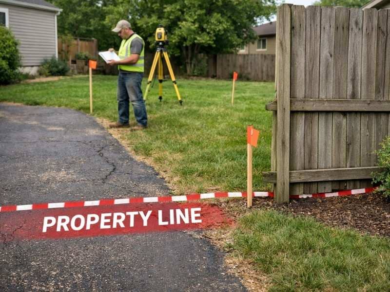
Land surveyor reviewing property boundaries near a fence and driveway during a residential property encroachment survey

Property disputes between neighbors are more common than most people realize. One of the most frequent causes is an encroachment, and many property owners do not even know they have one until a survey is done or a sale falls through.

An encroachment happens when a structure or object crosses over a property line onto land that belongs to someone else. It does not have to be intentional. Most happen by accident, when a fence gets built in the wrong spot or a driveway gets paved a few feet too wide. But whether intentional or not, an encroachment is a legal issue that needs to be addressed.

Common Types of Property Encroachments

Encroachments come in many forms. Some are easy to spot. Others go unnoticed for years.

Fences

A fence built even a foot or two over a property line is one of the most common encroachments. It often happens becawuse the owner assumed where the line was instead of having it properly marked by a surveyor.

Buildings and Structures

A garage, shed, or addition that extends beyond the property line is a serious encroachment. These are harder to deal with because they involve permanent structures.

Driveways and Pavement

A driveway poured slightly too wide can cross into a neighbor’s yard. This type is easy to miss but shows up clearly on a survey.

Overhanging Trees and Landscaping

Tree branches that hang over a property line or roots that spread beneath it are encroachments in many states. Retaining walls, steps, and landscaping features can also cross property lines.

How Are Encroachments Discovered?

Most encroachments are discovered in one of three ways:

During a land survey. A boundary or ALTA survey shows the exact location of all structures relative to the property lines. This is the most reliable way to find out whether an encroachment exists and how significant it is.

During a real estate transaction. Lenders and title companies often catch encroachments when reviewing survey documents before closing. This can delay or derail a sale if not resolved quickly.

During a neighbor dispute. Sometimes a disagreement between neighbors is what triggers a survey, and the survey reveals an encroachment that neither party was aware of.

What Happens If You Ignore an Encroachment?

Ignoring an encroachment does not make it go away. It can actually make things worse.

It can complicate the sale of your property. Buyers, lenders, and title companies will flag an unresolved encroachment and may refuse to move forward until it is fixed.

In some states, a person who uses a strip of your land openly for long enough may eventually claim legal rights to it. This is called adverse possession. The time period required varies by state, but the risk grows the longer an encroachment is left alone.

The longer an encroachment stands, the harder and more expensive it is to resolve.

What Can You Do About a Property Encroachment?

If you discover a property encroachment, your first step is to get a licensed land survey to confirm the exact location of the property lines. Once you have that documentation, you can approach the situation through a neighborly agreement, a formal easement, or legal action if needed.

Step 1: Get a Survey

Before doing anything else, make sure you have a current, accurate boundary survey. You need documented proof of where the property lines are before you can make any legal claim or have a productive conversation with your neighbor.

Step 2: Talk to Your Neighbor

Most encroachments are not intentional. A calm, factual conversation backed by survey documentation often leads to a quick resolution. The neighbor may agree to remove the fence, adjust the driveway, or trim the overhanging branches.

Step 3: Consider a Written Agreement

If the encroaching structure is difficult or expensive to remove, both parties may agree to handle it through a formal encroachment agreement. This is a legal document that acknowledges the encroachment, defines the terms under which it can remain, and protects both parties.

Some property owners choose to grant a neighbor an easement over the affected strip of land instead. This is a more permanent solution that is recorded with the county and stays with the property.

Step 4: Contact an Attorney

If the neighbor refuses to cooperate or the encroachment involves a major structure, you may need legal help. A real estate attorney can advise you on your rights and help you pursue a resolution through the courts if necessary.

What If You Are the One Encroaching?

Finding out your structure crosses a property line is stressful, but it is better to know.

  • Do not remove anything until you have talked to the neighbor and possibly an attorney
  • Review the survey to understand exactly how much the encroachment measures
  • Consider whether the structure can be adjusted or whether a formal agreement makes more sense
  • Act in good faith and communicate openly. Most neighbor encroachments are resolved without going to court.

The worst thing you can do is ignore the problem after it has been raised.

How Much Does It Cost to Resolve an Encroachment?

The cost depends on what kind of encroachment it is and how it gets resolved.

  • Survey to confirm the issue: $300 to $1,500 depending on property size
  • Moving a fence: Typically $500 to $2,000 depending on length and materials
  • Legal fees if a dispute goes to court: Varies widely, but can reach thousands of dollars
  • Formal encroachment agreement or easement: Usually a few hundred dollars in legal and recording fees

Resolving an encroachment early and informally is almost always cheaper than letting it become a legal dispute.

Frequently Asked Questions

Can my neighbor force me to remove a structure that encroaches on their property? 

Yes. A property owner has the legal right to require the removal of any structure that crosses their property line. If you refuse, they can take the matter to court and a judge can order removal, sometimes at your expense.

How do I know if my fence is on the property line? 

The only reliable way to know is to have a licensed land surveyor locate and mark your property corners. Do not rely on an old fence line or a neighbor’s claim about where the line is.

Does homeowners insurance cover encroachment disputes? 

Generally no. Most homeowners insurance policies do not cover legal disputes over property lines. You would typically need to pay legal and survey costs out of pocket.

Can an encroachment affect my ability to sell my home? 

Yes. Unresolved encroachments are a common reason real estate transactions get delayed or fall through. Lenders and title companies flag them during the closing process.

Posted in boundary surveying | Tagged boundary survey

What Is a Property Easement and How Does It Affect Your Land?

Panama City Land Surveying Posted on June 5, 2026 by PCBSurveyorMay 27, 2026
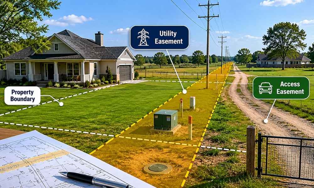
Aerial view of a residential property showing boundary lines and a utility easement area across the land

When you buy a piece of land, you expect to own everything on it and have full say over how it is used. But that is not always the case. Some properties come with easements attached, and if you do not know about them, you could be in for a big surprise.

An easement is a legal right that allows someone else to use part of your property for a specific purpose. The person or organization holding the easement does not own your land. They simply have the right to use a portion of it in a certain way. That right stays with the land, which means it transfers to the new owner when the property is sold.

Why Do Easements Exist?

Easements exist because land is not always arranged in a way that gives everyone fair access to what they need. A neighbor’s property might be completely surrounded by other lots with no road access. A utility company may need to run a power line across private land to reach a neighborhood. A city may need a strip of land for a drainage pipe.

Rather than forcing a sale of part of the land, the law allows these needs to be met through an easement. The property owner keeps ownership. The other party gets limited, specific use rights.

Common Types of Property Easements

Utility Easements

Utility easements are the most common type. They give power companies, water authorities, cable providers, and other utilities the right to install and maintain lines, pipes, and equipment on your property.

If you have overhead power lines crossing your yard or a water main running under your driveway, there is likely a utility easement in place. You cannot build a permanent structure, like a garage or shed, over or within the easement area without permission.

Access Easements (Right-of-Way)

An access easement gives someone the legal right to cross your property to reach another location. This is common in rural areas where one property sits behind another with no direct road access.

For example, if your neighbor’s land is landlocked behind yours, they may have a legal right to drive across a section of your property to reach the public road. That right cannot be taken away, even if you sell your land to someone else.

Drainage Easements

Drainage easements allow water to flow across a section of property through pipes, ditches, or natural channels. Local governments and developers often create these to manage stormwater in neighborhoods. Property owners within a drainage easement area usually cannot fill in ditches, block flow paths, or plant large trees that could damage drainage infrastructure.

Conservation Easements

A conservation easement is a voluntary agreement between a landowner and a land trust or government agency. The owner keeps the property but gives up the right to develop it in ways that would harm its natural or agricultural value. These protect forests, wetlands, farmland, and scenic land.

How Is an Easement Created?

Easements can be created in several ways:

  • By deed. The most common way. The easement is written into the property deed or a separate recorded document.
  • By plat. When land is subdivided, the plat map often shows utility and access easements for each lot.
  • By necessity. A court can grant an easement when a property has no legal way to reach a public road.
  • By prescription. If someone uses part of your land openly for a long period without permission, they may be able to claim a legal right to continue. The required time period varies by state.

How Does an Easement Affect Your Property?

An easement limits what you can do with the portion of your land it covers. You still own the land, but you cannot interfere with the easement holder’s legal right to use it. This can affect where you build structures, where you plant trees, and in some cases, the value of your property.

Here is what easements mean in practical terms:

  • You cannot build a structure in an easement area without written approval from the easement holder
  • The easement holder may enter your property to maintain equipment or infrastructure
  • You are still responsible for property taxes on the easement area
  • If you violate an easement, you can be taken to court and required to remove whatever was built

Most easements only affect a narrow strip of land, not the entire property.

How Do You Find Out If Your Property Has an Easement?

  • Check the deed. Easements are often listed in the property deed or chain of title documents.
  • Review the plat map. The recorded plat for your subdivision usually shows easements on each lot.
  • Order a title search. A title company can identify all recorded easements in the ownership history.
  • Get a survey. An ALTA survey is the most thorough option. It shows exactly where each easement sits on the ground.

If you are buying property, always check for easements before closing. Some are obvious. Others only appear through a careful title search or survey.

Can an Easement Be Removed?

Yes, but it takes a formal process. An easement can end if the holder gives up the right in writing, the purpose no longer exists, both parties agree to end it, or a court orders its removal. Simply ignoring an easement for years does not cancel it. One created by deed stays on record until it is formally released.

Frequently Asked Questions

Can I fence off an easement area on my property? 

It depends on the type of easement. For utility easements, you may be able to install a fence but must leave access for maintenance crews. Check the easement language before putting up any barriers.

Does an easement lower my property value? 

It can, depending on the type and location. A small utility easement along the back edge of a lot typically has little impact. A large access easement that cuts through the middle of a yard can reduce usable space and affect resale value.

What if someone is using my land without an easement? 

That is called an encroachment, and it is a separate legal issue from an easement. You should contact a licensed surveyor to document the situation and speak with an attorney about your options.

Do easements show up on a property survey? 

Yes, depending on the survey type. A boundary survey notes recorded easements in the legal description. An ALTA survey shows them on the map with their exact location and dimensions.

Posted in boundary surveying | Tagged boundary survey

Post navigation

← Older posts
Newer posts →
Get Quote Button
Panama City Land Surveying<
Panama City, Florida
Phone: (850) 640-6404

Privacy Policy | Terms of Use

Web Development and SEO by:
AuburnBusiness.com, LLC

The owner of this website, Boxer Survey USA, provides coordination of professional land surveying and engineering services in all 50 states. The professional surveying and engineering services provided to you will be conducted by fully licensed professionals in your state.

©2026 - Panama City Land Surveying - Weaver Xtreme Theme
↑