
↓
 

Panama City Land Surveying

Local Land Surveyors in Panama City, Florida

Panama City Land Surveying
  • Home
  • ALTA Survey
  • Boundary Surveying
  • Construction Survey
  • Drone LiDAR Mapping
  • Elevation Certificate | Flood Survey
  • Land Surveying
  • Topographic Survey
  • Blog
  • Contact Us
Home - Page 3 << 1 2 3 4 5 … 9 10 >>

Post navigation

← Older posts
Newer posts →

What Is an ALTA Survey and When Is It Required?

Panama City Land Surveying Posted on June 3, 2026 by PCBSurveyorMay 24, 2026
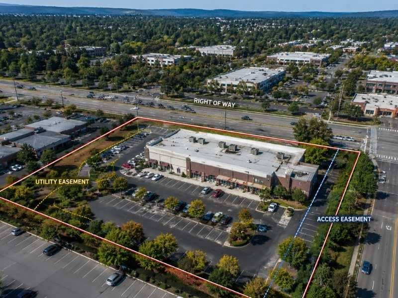
Aerial view of a commercial property with highlighted boundary lines and easement areas commonly reviewed during an ALTA land survey

If you have ever been involved in a commercial real estate deal, you may have heard someone mention an ALTA survey during the closing process. It sounds like a technical term, but the idea behind it is simple.

An ALTA survey is the most detailed type of land survey available. It gives lenders and title insurance companies a full picture of a property before a major transaction takes place. It does much more than measure property lines. It records everything that could affect who owns the land, how it can be used, and what it is worth.

What Does ALTA Stand For?

ALTA stands for the American Land Title Association. The survey standard is created together with the National Society of Professional Surveyors (NSPS).

These two groups wrote a set of national rules that every ALTA survey must follow, no matter which state the property is in. Most other survey types follow state rules, which can be different from place to place. An ALTA survey uses the same rules everywhere in the country. That matters to banks and title companies that handle deals in many different states.

What Does an ALTA Survey Include?

An ALTA survey includes everything in a standard boundary survey, plus a detailed look at easements, utility lines, encroachments, access points, flood zone status, and zoning. It follows national standards set by ALTA and NSPS and is required for most commercial real estate transactions.

A standard ALTA survey covers:

  • The exact location of all property boundary lines
  • All buildings and improvements on the property
  • Easements and rights-of-way that cross or border the land
  • Visible utility lines above and below ground
  • Encroachments from or onto neighboring properties
  • Driveways and road access points
  • Parking areas and their dimensions
  • Flood zone status from FEMA maps
  • Zoning classification from the local government

The survey also identifies items found in the title commitment. A title commitment is a document the title company prepares before closing that lists known issues with the property. If that document mentions an easement or restriction, the ALTA survey shows exactly where it sits on the ground.

How Is an ALTA Survey Different From a Boundary Survey?

A boundary survey answers one question: where are the property lines? An ALTA survey starts with that same answer and then adds much more information on top of it.

A simple way to think about it: a boundary survey is the foundation. An ALTA survey is the whole building.

FeatureBoundary SurveyALTA Survey
Property linesYesYes
Corner monumentsYesYes
Easements shownSometimesAlways
Utility linesNoYes
EncroachmentsSometimesYes
Flood zone statusNoYes
Zoning informationNoYes
National standardsNoYes
Typical useResidentialCommercial

When Is an ALTA Survey Required?

An ALTA survey is required by lenders and title companies before closing on a commercial real estate purchase, refinance, or large development project. It is rarely needed for a standard home purchase but is standard in almost every commercial transaction.

Commercial Purchases and Refinancing

When a business or investor buys commercial property, the lender almost always requires an ALTA survey before approving the loan. The same is true when a commercial property is refinanced. The bank needs to know exactly what it is lending money against.

Before Title Insurance Is Issued

Title insurance protects the buyer and lender if a problem with the property’s ownership comes up after closing. Before a title company will issue this protection on commercial property, it needs the full documentation that only an ALTA survey provides.

Large Developments and National Lenders

Developers building apartment complexes or mixed-use projects often need an ALTA survey for permitting and financing. Banks that work across many states also require them because the national standards give a consistent, reliable document no matter where the property is.

Who Performs an ALTA Survey?

Only a licensed Professional Land Surveyor can perform an ALTA survey. The surveyor must follow the current ALTA/NSPS standards, and the version used must be listed on the face of the survey.

The title company usually gives the surveyor two things to work with: a copy of the title commitment and a list of specific items called Table A items. These are the extra details the lender or buyer wants included. Some are standard. Others are optional add-ons.

How Much Does an ALTA Survey Cost?

An ALTA survey for a smaller commercial property usually costs between $2,000 and $6,000. Larger or more complex sites can cost $10,000 or more depending on acreage, improvements, and the items requested.

ALTA surveys cost more than other surveys for a few clear reasons:

  • More research. The surveyor must study title documents and easement records before going to the field.
  • More fieldwork. Every building, utility line, and access point must be found and measured.
  • Strict rules. Meeting the ALTA/NSPS standards takes more time in both the field and the office.
  • Higher stakes. These surveys are used in high-value deals, and that responsibility is part of the fee.

For a commercial property worth hundreds of thousands or millions of dollars, the cost of an ALTA survey is a small price to pay for that level of detail and protection.

Frequently Asked Questions

Do I need an ALTA survey to buy a house? 

Usually not. Most home purchases use a standard boundary survey or an existing one already on file. ALTA surveys are for commercial deals. If you are buying a larger property or one with a commercial use, ask your lender whether one is required.

How long does an ALTA survey take? 

Most take two to four weeks after the order is placed. Properties with complicated easement histories or large acreage can take longer.

What are Table A items? 

Table A is a list of extra details that can be added to the survey. Examples include the location of parking spaces, underground utilities, or the square footage of buildings. Each item adds information and may add cost.

Can an ALTA survey replace a boundary survey? 

Yes. An ALTA survey meets or exceeds everything a boundary survey covers, so it works wherever a boundary survey is needed. But a basic boundary survey cannot be used in place of an ALTA survey for commercial loans or title insurance.

Posted in alta survey | Tagged alta survey

Boundary Survey vs. Property Survey: What’s the Difference?

Panama City Land Surveying Posted on June 1, 2026 by PCBSurveyorMay 24, 2026
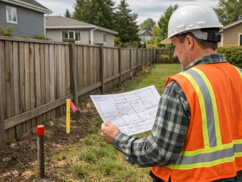
Land surveyor reviewing a property survey map beside boundary markers and a fence line in a residential neighborhood

If you have been looking into getting your land surveyed, you have probably seen both of these terms. Boundary survey. Property survey. They sound like two different things, but most of the time they are referring to the same service.

Here is the short answer: a boundary survey and a property survey are the same type of survey. “Property survey” is simply the everyday term that most homeowners use. “Boundary survey” is the professional term that licensed surveyors and legal documents use. Both refer to the process of officially measuring and marking the legal edges of a piece of land.

That said, “property survey” can sometimes be used loosely to describe other types of surveys, which is where the confusion starts. This article will clear that up and explain exactly what a boundary survey does, when you need one, and what to expect.

What Is a Boundary Survey?

A boundary survey is an official measurement of a property’s legal edges. A licensed surveyor researches historical records, measures the land, and places permanent markers at the corners. The result is a legal document showing exactly where one property ends and another begins.

A boundary survey answers one basic question: where exactly does your property begin and end?

To answer that question, a licensed land surveyor does several things:

  • Reviews the legal description and deed for the property
  • Searches public records for historical surveys, plats, and deeds going back as far as needed
  • Visits the site and looks for existing property corner monuments
  • Takes precise field measurements across the property
  • Places permanent markers, called monuments or pins, at the legal corners
  • Prepares a plat or survey map showing the exact boundary lines and dimensions

The finished survey becomes a legal document. It can be used in court, filed with the county, and referenced in future real estate transactions.

What Are Property Pins?

Property pins are small metal stakes, usually iron or steel, that a surveyor drives into the ground to mark the corners of a property. You can sometimes find them with a metal detector just below the surface.

These pins are legally protected. Moving or removing one without authorization is a crime in most states. If you find a pin that looks disturbed, contact a licensed surveyor before acting on its location.

When Do You Need a Boundary Survey?

You need a boundary survey any time there is a question about where your property lines are. Common situations include buying or selling land, building near a property edge, settling a neighbor dispute, installing a fence, or dividing a parcel into smaller lots.

Before Buying or Selling Land

A boundary survey confirms that the property you are buying matches what is described in the deed. Without one, you could end up owning less land than you paid for, or find out after the sale that a structure sits on a neighbor’s property.

Before Building Near a Property Line

Zoning laws require buildings, fences, and other structures to sit a set distance from the property line. This is called a setback. Before starting any construction near the edge of your lot, a boundary survey tells you exactly where that line is so you stay within the rules.

When a Neighbor Dispute Comes Up

Disagreements over property lines are one of the most common reasons people hire a surveyor. A boundary survey provides a legal, documented answer that both parties and the courts can rely on.

Before Installing a Fence

Installing a fence along a line you only think is correct can lead to encroachment disputes and expensive removal costs later. A boundary survey makes sure your fence goes up in the right place the first time.

When Dividing Land

If you want to split a large parcel into smaller lots to sell or develop, a boundary survey is required. Each new lot must have its boundaries legally established and recorded.

What Does a Boundary Survey Produce?

When the survey is complete, the surveyor provides:

  • A plat or survey map showing the property boundaries, dimensions, and corner monuments
  • A legal description of the boundary lines
  • Notes on any encroachments, easements, or overlaps found during research
  • The surveyor’s stamp and signature, which gives the document legal standing

The plat can be filed with the local county recorder’s office to become part of the public record, protecting you and all future owners of the property.

How Long Does a Boundary Survey Take?

For a standard residential lot, the process typically takes one to three weeks from the time you place the order to the time you receive the finished plat. Properties with unclear historical records or large rural acreage can take longer.

How Much Does a Boundary Survey Cost?

A boundary survey for a standard residential lot typically costs between $300 and $1,500. Larger rural properties, irregular shapes, or parcels with complex ownership histories can cost $2,000 or more.

The main cost factors are:

  • Lot size and shape. Larger or oddly shaped parcels take more time to measure.
  • Research difficulty. Properties with unclear deed histories or missing records take longer to research.
  • Existing monuments. If previous corner pins are missing or damaged, the surveyor must do more work to re-establish the corners.
  • Location. Rates vary by region and local market conditions.

Discovering a boundary problem after construction or a sale is far more expensive to fix than the cost of the survey itself.

Frequently Asked Questions

Do I already have a boundary survey from when the house was built? 

You might. Check your closing documents or contact the county property records office. If a survey was done, it may be on file. Keep in mind that an older survey may not reflect current conditions, especially if the land has been divided or if neighboring properties have changed.

Can I use Google Maps or online tools to find my property lines? 

No. Online mapping tools are not legally accurate and should never be used to make decisions about construction, fences, or property disputes. Only a survey done by a licensed land surveyor has legal standing.

What is encroachment? 

An encroachment happens when a structure, like a fence, building, or driveway, crosses over a property line onto a neighbor’s land. Boundary surveys often reveal encroachments that owners did not know existed.

Is a boundary survey required to get a mortgage? 

Not always. Some lenders accept an existing survey, while others require a new one. Check with your lender and title company before closing to find out what is needed.

Posted in boundary surveying | Tagged boundary survey

What Is an As-Built Survey?

Panama City Land Surveying Posted on May 29, 2026 by PCBSurveyorMay 24, 2026
Survey team reviewing construction site records and measurements at a completed building project for an as-built survey

When a building project is finished, the actual work on the ground does not always match the original plans exactly. Small changes happen along the way. A wall may shift a few inches. A utility line gets rerouted. The grading gets adjusted in the field. An as-built survey captures all of those changes and creates an official record of what was actually built.

Think of it this way. A design plan shows what a project is supposed to look like before work begins. An as-built survey shows what it actually looks like after the work is done. One is the plan. The other is the proof.

What Does an As-Built Survey Record?

An as-built survey records the exact location and size of everything that was built on a property. The specific items depend on the type of project, but most as-built surveys include:

  • The position of buildings and structures on the lot
  • Foundation dimensions and finished floor elevations
  • The location of driveways, parking areas, and walkways
  • Underground utility lines such as water, sewer, gas, and electrical conduits
  • Stormwater pipes, drainage inlets, and retention areas
  • Retaining walls, fences, and other site improvements
  • Final ground elevations around structures

For commercial and civil projects, this documentation can be very detailed. It may include hundreds of data points showing the exact depth and position of every buried utility line on the property.

When Do You Need an As-Built Survey?

You need an as-built survey after construction is finished on any project that requires a building permit or engineering plans. It is commonly required by local governments, lenders, and utility companies before a project can be officially closed out.

After New Construction

Most local governments require an as-built survey before they will issue a certificate of occupancy. This is the official document that allows a building to be used or lived in. Without it, the project cannot be legally occupied, no matter how well the work was done.

For Permit and Code Sign-Off

Building departments use as-built surveys to confirm that what was built matches the approved plans. If changes were made during construction, those changes need to be on record. An as-built survey is the official proof that the finished work meets local codes.

Before Renovations or Additions

If you want to add on to a building or make major changes to a property, your contractor and engineer need accurate records of what is already there. Older properties often do not have reliable documents on file. An as-built survey gives the design team a current, accurate starting point.

For Real Estate and Lending

Buyers, lenders, and title companies sometimes need as-built records to confirm that the improvements on a property are in the right place. This comes up often in commercial real estate sales and refinancing situations.

For Utility Companies

Utility companies frequently require as-built surveys after installing new lines or systems underground. Knowing exactly where those lines are buried protects workers and prevents damage during future digging or nearby construction.

Who Typically Requires an As-Built Survey?

  • Local building departments to issue a certificate of occupancy
  • Lenders and banks before closing out a construction loan
  • Title insurance companies to confirm improvements match the property records
  • Utility companies after new underground systems are installed
  • Future owners or contractors who need reliable records of what is on the site

How Is an As-Built Survey Done?

A licensed land surveyor visits the finished property and takes careful measurements of all the improvements that were built. For things you can see on the surface, like buildings and driveways, the surveyor records where they sit in relation to the property lines.

For buried utilities, the process works best when the surveyor is on site during construction, before the trenches are filled in. Once a pipe or conduit is underground, finding it again without digging is very difficult.

All the field measurements are brought back to the office and used to create a finished drawing. That drawing becomes the permanent record of the property as it was built.

According to the Construction Industry Institute, poor as-built documentation is one of the top causes of cost overruns during future renovation and expansion work. Good records from the start prevent those problems.

How Much Does an As-Built Survey Cost?

An as-built survey for a home typically costs between $400 and $1,500. Larger commercial projects can range from $1,500 to $5,000 or more, depending on the size of the site and how much needs to be documented.

Here are the main things that affect the price:

  • Size of the property. Larger sites with more improvements take more time to document.
  • Underground utilities. Recording buried lines adds time and complexity to the work.
  • Number of improvements. One building is simpler than a site with multiple structures, parking lots, and utility systems.
  • Turnaround time. Faster delivery usually costs more.

The cost of an as-built survey is small compared to what can go wrong without one. Contractors who accidentally damage an unmarked underground line face repair costs, project delays, and legal liability. Accurate records help prevent all of that.

Frequently Asked Questions

Is an as-built survey the same as a record drawing? 

They are similar but not exactly the same. A record drawing is usually prepared by the engineer or contractor using their own field notes. An as-built survey is done by a licensed land surveyor using direct measurements. The as-built survey is more precise and has more legal weight.

Do I need one for a small backyard project? 

For simple work like a fence or a small shed, an as-built survey is usually not needed. But if the project involves a permit, underground utilities, or major grading changes, check with your local building department to find out what records are required.

How long does it take? 

The field work for a standard residential project usually takes one day or less. The finished drawing is typically ready within one to two weeks after the site visit.

Do I need to keep the as-built survey after the project is done? 

Yes. Keep it for as long as you own the property. It is one of the most useful documents you can have if you ever plan to renovate, sell, or refinance. Lenders and contractors will thank you for having it.

Posted in land surveying | Tagged Land Surveying

Post navigation

← Older posts
Newer posts →
Get Quote Button
Panama City Land Surveying<
Panama City, Florida
Phone: (850) 640-6404

Privacy Policy | Terms of Use

Web Development and SEO by:
AuburnBusiness.com, LLC

The owner of this website, Boxer Survey USA, provides coordination of professional land surveying and engineering services in all 50 states. The professional surveying and engineering services provided to you will be conducted by fully licensed professionals in your state.

©2026 - Panama City Land Surveying - Weaver Xtreme Theme
↑