
What Is a Topographic Survey and When Do You Need One?
Before anyone builds or designs anything on a piece of land, they need to know what that land actually looks like. That is exactly what a topographic survey does.
A topographic survey measures and maps the physical features of a property. It records the shape of the ground, the height of the land at different points, and everything sitting on it, both natural and man-made. Engineers, architects, and contractors use this map before any project begins.
What Does a Topographic Survey Show?
A topographic survey captures two things: what is on the land and how the height of the land changes from one spot to another.
Natural Features
- Hills, ridges, and valleys
- Streams, ponds, wetlands, and drainage channels
- Tree lines and large areas of vegetation
- Rock formations and changes in soil
Man-Made Features
- Existing buildings and structures
- Roads, driveways, and parking areas
- Fences, walls, and utility poles
- Underground utility lines (when marked by the utility company)
Elevation and Contour Lines
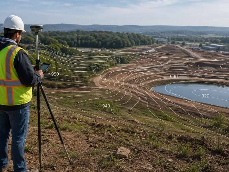
Elevation is simply how high or low a point of land is. During a topographic survey, surveyors collect hundreds or thousands of elevation readings across the property.
Those readings are used to draw contour lines on the map. A contour line connects all the points that share the same elevation. When contour lines are close together, the land is steep. When they are spread apart, the land is flat or gently sloping. This makes it easy to see how water will move across a property after it rains.
When Do You Need a Topographic Survey?
You need a topographic survey before designing or building on land where the slope, drainage, or ground features are unknown. It is also required for flood studies, stormwater permits, and most commercial site plan applications.
Before Any Site Design
Architects and engineers cannot design a site correctly if they do not know the shape of the land. A house built without this information can end up with water draining toward the foundation, a driveway too steep to use, or a septic system in the wrong spot. A topographic survey helps the design team avoid all of those problems.
For Drainage and Stormwater Plans
When you build on land, rainwater behaves differently than before. Local governments require developers to show how water will drain off the finished site. Engineers use topographic data to plan retention ponds, drainage channels, and culverts that manage stormwater safely.
For Flood Zone Studies and Permits
If a property is near water, a topographic survey is often required for a flood study. Accurate elevation data helps determine if the land sits in a flood zone. Many local governments also require a topo survey before approving permits for new subdivisions and commercial developments.
For Grading and Landscaping
Contractors doing large grading or landscaping work use topographic data to calculate how much soil needs to be moved. This helps them plan more accurately and avoid costly surprises on the job.
What Does the Final Map Look Like?
The finished product is usually a digital map file in CAD or GIS format. Engineers and architects use it as the starting point for all their design work.
The map includes:
- Contour lines at set height intervals, usually every 1 or 2 feet
- Spot elevations at key locations like building corners and drainage points
- A legend, a scale, and a north arrow
- The licensed surveyor’s stamp and signature
Smaller residential projects also usually include a printed copy of the map.
How Does It Compare to Other Surveys?
| Survey Type | What It Does |
| Topographic Survey | Maps the height and features of the land |
| Boundary Survey | Shows where the property lines are |
| Construction Survey | Marks where a building or road will be built |
| As-Built Survey | Records what was actually built after construction |
A topographic survey almost always comes before a construction survey. The topo gives engineers the data they need to create a design. Once approved, a construction surveyor marks the site based on that design.
How Much Does a Topographic Survey Cost?
A topographic survey for a home lot usually costs between $500 and $2,000. Larger properties can range from $2,000 to $8,000 or more, depending on size, terrain, and the level of detail needed.
Key factors that affect the price:
- Acreage. More land means more measurements and more time.
- Terrain. Wooded or hilly sites take longer to work through.
- Level of detail. A 1-foot contour interval survey takes more time than a 2-foot one.
- File format. Specific CAD or GIS formats may add time to the process.
Finding a design problem on paper is always cheaper than finding it after construction has started.
How Is a Topographic Survey Done?
A licensed surveyor and a field crew visit the property and collect elevation readings using GPS equipment, robotic total stations, or drones with LiDAR scanning. The data is processed back at the office, where software creates the contour lines and final map. Depending on the project size, this takes anywhere from a few days to two weeks.
According to the American Society of Civil Engineers (ASCE), inaccurate elevation data is one of the top causes of home flooding and foundation damage in the United States. A topographic survey is the first step in preventing those problems.
Frequently Asked Questions
Do I need a topographic survey for a small home addition?
Usually not. But if the project involves grading, a foundation on a slope, or drainage concerns, your engineer or local building office may request one.
Can a topographic survey become outdated?
Yes. If major grading or construction has happened on the property after the survey was done, the map may no longer be accurate. Most engineers prefer data that is no more than a few years old.
How accurate is a topographic survey?
Ground-based surveys are accurate to within a fraction of an inch. Drone surveys are accurate to within 1 to 3 inches, which works well for most grading and planning but may not be precise enough for detailed engineering.
Is a topographic survey the same as a contour map?
No. The survey is the process of collecting elevation data. The contour map is the finished drawing that comes from that data.